Plan of action for the development of Digital Twin for dike strength calculations
The DigiShape seed money project Digital Dike from 2025 has been completed. The Hollands Noorderkwartier Water Board (HHNK), Deltares and BZ Ingenieurs & Managers investigated how existing data about dikes and their subsurface can be brought together in a reliable 3D model. This is the next step towards a Digital Twin that can support dike managers with dike strength calculations. Project leader Karel Hagemans of BZ Ingenieurs & Managers explains.
What problem did you want to solve with Digital Dike?
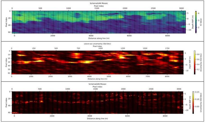
A lot of data is available about dikes and their subsurface, for example from drilling and CPTs. However, these measurements mainly provide information about individual locations. A dike strength calculation requires a coherent picture of the structure of the dike and the subsoil. Digital Dike is investigating how to combine existing measurement data into a reliable 3D model, from which profiles for dike strength calculations can then be derived.
What exactly have you developed or researched within Digital Dike?
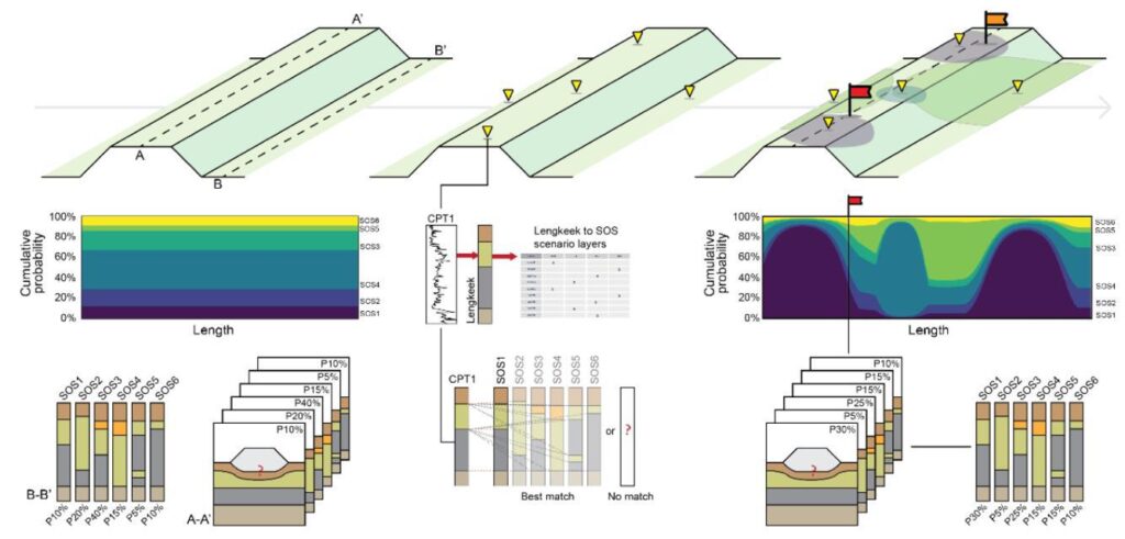
We have developed a plan of action that forms the basis for the development of a Digital Twin prototype. This worked out how different data sources can be combined into a consistent 3D representation of the dike structure. It also describes how profiles can be made from that model at a chosen location that are suitable for dike strength calculations in D-Stability and DAM.
In addition, various interpolation methods were examined. These are necessary to create a coherent picture of the subsurface on the basis of separate measuring points. Which method is suitable depends, among other things, on the amount and quality of the available data.
Which parties collaborated on Digital Dike and what did they contribute?
HHNK mainly contributed the practical knowledge and user needs. This was important to shape the structure of the working method. Deltares contributed the substantive and research-based knowledge about the interpolation methods and how the model itself can be constructed. BZ Engineers & Managers contributed expertise on dike data in the life cycle of the dike and further developed the plan and working method. The combination was important to combine technical knowledge with practical experiences of the manager.
What does the intended proof of concept look like and how do you want to test whether the approach works?
The proof of concept would be the next step, in which we test whether the approach works in practice. It is important that a profile from the 3D model can not only be generated, but also substantiated. You must be able to see which CPTs, boreholes and laboratory data underlie it and which interpolation method has been used.
For validation, the outcome will be compared with new, independent measurement data, existing 2D schematizations from HHNK and the existing Digital Twin of the Purmerringdijk. This allows us to assess both technical accuracy and practical usability.
Which data types have you described in the plan of action, to build the future model?
Surface data and point observations of the subsurface. The surface data concerns the AHN and lidar measurements for the height profiles of the barriers. The subsurface of the model is mainly built up on the basis of point observations, such as drilling and CPT probes. Geophysical measurements may be added for additional insight.
What is the intended added value compared to the systems, maps or models that a dike manager already uses?
The added value lies mainly in combining existing data into one traceable 3D model. From that model, you can create targeted profiles and at the same time keep insight into the underlying data and assumptions.
Are end users already working with it and how?
HHNK is closely involved as an end user and has therefore had an influence on the development of the plan of action from the start. Together with HHNK, it is discussed which steps will now be taken first to realize the plan of action in practice.
What went well in the project and what could have been better?
The strong side was the combination of technical development and a clear practical question. From the start, we looked at the usability for existing processes and systems applied by the end user, HHNK, such as D-Stability and DAM.
One learning point is that we could have worked out more specifically how geophysical data can be included in the future Digital Twin and what added value that data can have for the model.
What is the most important next step after completion of the seedmoney project?
Determine the location and then inventory and collect the available data and data systems. Together with HHNK, we are looking at what steps are needed to implement the plan of action and to further develop the model and proof of concept.
What is the most important revenue of Digital Dike for you and what step has the seed money made possible?
Thanks to the seed money, we were able to develop the idea in concrete terms: what data are needed, which methods are promising and how can this connect to existing systems? This now provides a clear basis for the first steps towards a Digital Twin for HHNK.
More information: view the developed Plan of Action on the project page or contact Karel Hagemans, BZIM